top of page

MAP OF UPRA
Upra consists of three main regions: InFlate District, Big Balloon District, and Weluvdem District.
*All maps shown are provided by the News Propaganda Department of Upra (NPDU). NPDU is generated by AI and guided by the Administration Office.
InFlate District is the major site for research and studying. The circular high street, 49Glory Street, is the most academic road in Upra. Right inside the circular region bounded by 49Glory Street is the University of Divine Balloon (UDB), where the Further Education and Research Program takes place.
*The map is provided by the News Propaganda Department of Upra (generated by AI).

The Big Balloon District is the main residential activity area. The expressway, Can't Live Without You Street, traverses the whole area. Near the Can't Live Without You Street, there is a National Hall of Emblem, where the Weekly Lecture Session and concerts are held. The Blow It Street branches from the Can't Live Without You Street. Citizens can relish in national relics in the National Ballief-Raiyol Museum, which is situated by the side of the Blow It Street.
*The map is provided by the NPDU (generated by AI).

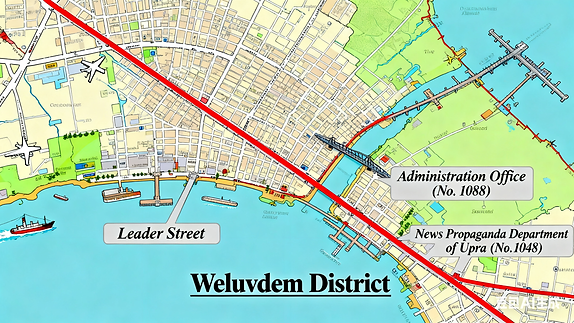
Weluvdem District is the administrative area of Upra. It contains the most bustling streets and busiest traffic sections.
The only overseas highway (shown red in the map) connects the most significant departments in Upra and the other two districts. There is also a marine highway (came from sea reclamation) called the Leader Street near the port. Near the entrance of the cross-sea bridge is the Administration Office (NO. 1088). Generations of leaders work in the Administration Office and issue important notifications. The News Propaganda Department of Upra (NO. 1048) is situated near the fork junction of the overseas highway. All the journalistic materials and important articles are produced right there.
*The map is provided by the NPDU (generated by AI).
bottom of page